This report delivers a remote analysis of building damage in Lebanon, leveraging insights from similar studies conducted in Gaza (2023-2024). Using Sentinel-1 satellite imagery and Microsoft building footprint data, the assessment identifies significant structural damage based on changes in reflectivity and displacement. Approximately 5,027 buildings across Lebanon show significant damage out of an estimated total of 600,000. Notably, 8,000 buildings lie within a 10 km radius of the southern border, a region particularly impacted. While this analysis provides critical initial guidance for humanitarian efforts, it underscores the need for field validation to enhance data accuracy and inform effective response strategies.
Summary of Findings
The analysis estimates:
- Buildings in Lebanon: ~600,000
- Severely Damaged buildings: 5,027.
- Moderate/light damaged buildings may be estimated as 10 to 15 times more severely damaged buildings
- Population impact: 878,000 displaced, 3,000 fatalities, 14,000 injuries, and 1 million needing assistance.
The El Nabatieh Governorate and the concentration of damaged high-rise buildings south of Beirut display the highest damage concentrations. Although current data is not accurate enough to determine light to medium damage, experience in other recent conflict zones, such as Ukraine, indicates that these categories are likely to be even more extensive as surrounding buildings commonly suffer secondary damage.
It must be noted that while the following assessment provides a relatively accurate overview at the national level, limitations in the quality of publicly available data reduce confidence and accuracy at the local level, increasing the importance of field verification.
Introduction
The following remote building damage analysis of Lebanon builds upon learnings from similar assessments conducted by Miyamoto in Gaza throughout 2023-24.
This assessment provides the most accurate analysis possible from the limited currently available data. Advanced machine learning was used to analyze publicly available pre- and post-damage Sentinel-1 satellite imagery, overlayed against Microsoft building footprint data, to determine significant changes in building reflectivity and displacement across the affected area as the primary indicator of damage.
This rapid assessment is intended to provide initial guidance to improve humanitarian response. It will be updated as more accurate data becomes available.
It must be noted that while the following assessment provides a relatively accurate overview, limitations in available data reduce confidence and accuracy at the local level, increasing the importance of field verification.
Lebanon Damage Assessment – Summary of Findings (November 27, 2024)
This assessment provides a detailed snapshot of the widespread damage in Lebanon, which has severely affected damaged approximately 5,000 of the 600,000 buildings nationwide, with a much greater number likely suffering light to moderate damage.
Table 1 Findings of extensive damage and humanitarian impact in Lebanon (Source: OCHA, MS building footprint, IOM)
| Category | Details |
| Total Buildings | ~600,000 nationwide |
| Buildings near Southern Border | ~8,000 (within 10km radius) |
| Significantly Damaged Buildings | ~5,027 |
| Moderate/light-damaged buildings may be estimated as 10 to 15 times more severely damaged buildings | |
| Displacement | 878,000 people |
| Casualties | ~3,000 deaths |
| Injuries | ~14,000 deaths |
| People Needing Basic Assistance | ~1 million |
Recovery efforts in recent conflicts such as Ukraine show direct blast damage to targeted buildings, resulting in significant minor damage to surrounding buildings, making rapid assessment and repairs of lighter damaged structures a likely rapid and effective emergency shelter solution for many. Field validation will be essential to confirm this analysis.
Severely Damaged Buildings Distribution
Conflict in Lebanon has resulted in disproportionate destruction across its governorates, with El Nabatieh bearing the heaviest toll, registering over 2,500 significantly damaged buildings.
However, ten times more in quantity for light and moderate damaged buildings are expected. In Mount Lebanon, damage is concentrated in areas more dominated by high-rise structures to the south and southeast of Beirut, reflecting the higher urban density. This analysis highlights the need for localized recovery efforts to address the unique challenges of each region, ensuring resources are allocated effectively to mitigate the uneven impact of the conflict and differing underlying housing typologies.
Table 2 Severely Damaged Buildings by Governorate
| Governorate | Damage Building |
| North | 22 |
| Baalbek-El Herme | 580 |
| Mount Lebanon | 602 |
| South | 822 |
| El Nabatieh | 2575 |
| Akkar | 6 |
| Bekaa | 419 |
| Beirut | 1 |
| 5027 |
*Moderately/lightly damaged buildings not counted above and may amount to a multiple of the quantities shown above
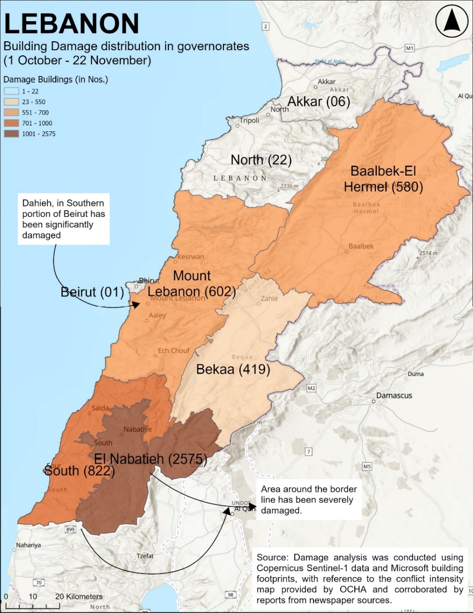
Figure 1 Lebanon Building Damage distribution governorates
Concentration of Building Damage
Damage is most heavily concentrated in the southern regions, the areas south and east of Beirut, and near Baalbek-El Hermel. These geographic hotspots provide critical information for prioritizing humanitarian and reconstruction efforts. The clustering of damage indicates the need for more focused interventions in more heavily impacted zones to restore infrastructure and livelihoods.
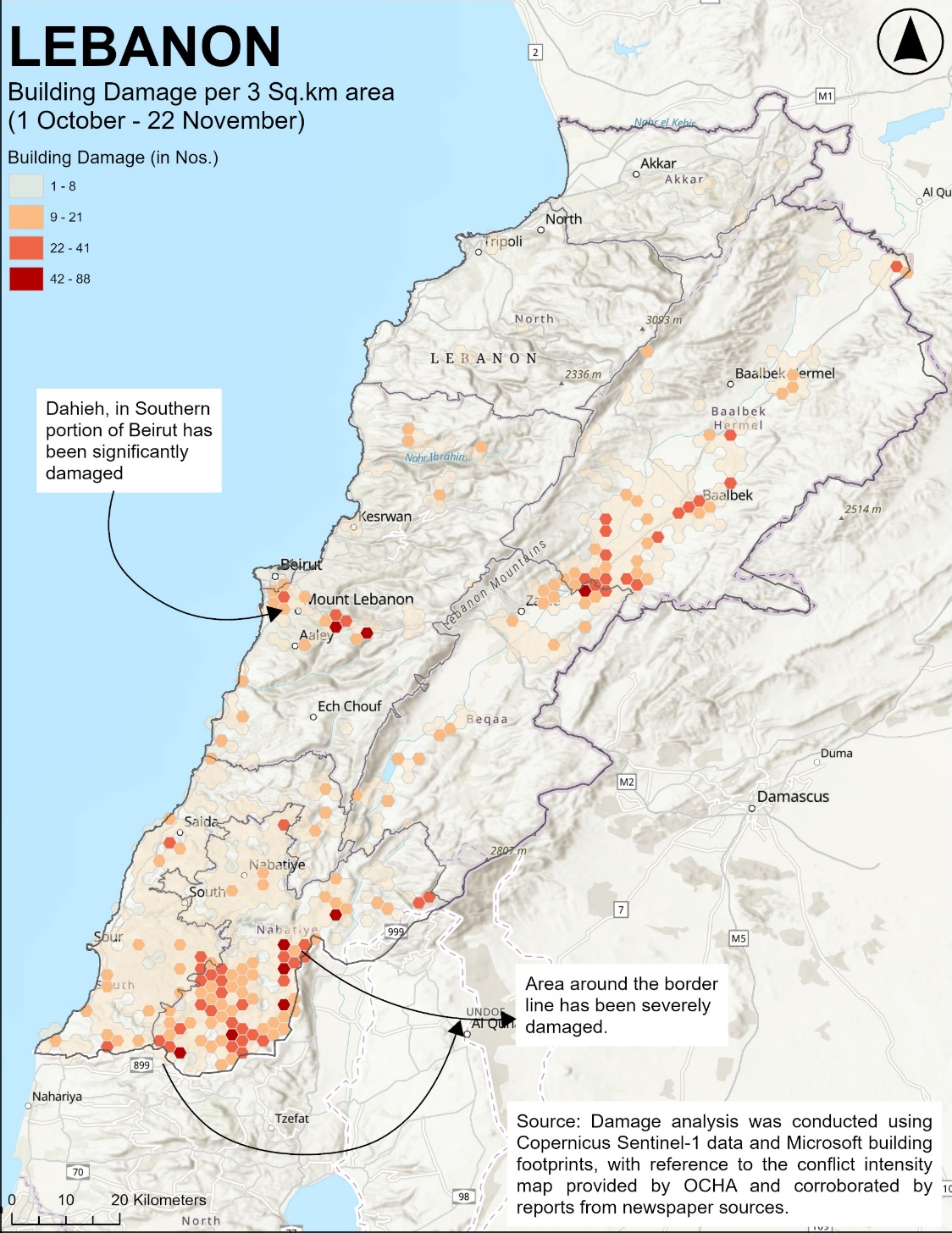
Figure 2 Lebanon Building Damage per 3 Sq.km area
Example of Remote Building Damage Analysis
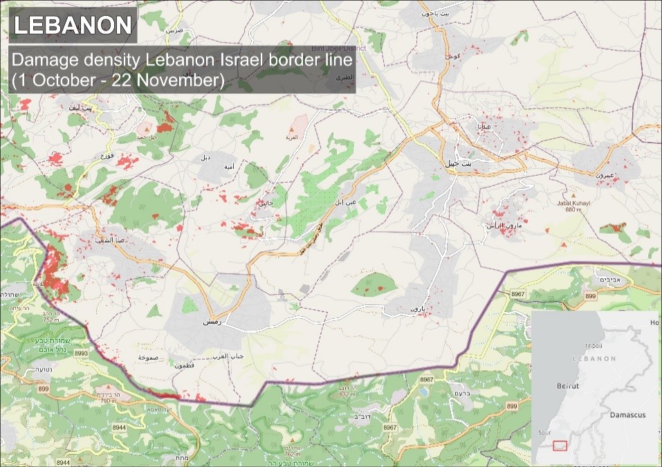
The following more granular samples from the assessment of the Lebanon-Israel border and Kfarkela showcase the methodology used to identify severe damage. These examples highlight significant clusters of destruction while also revealing limitations in the detection of minor and moderate damage. Such findings underscore the importance of combining remote assessments with ground-level validation to ensure a comprehensive understanding of the damage and to inform response planning effectively.
.
Figure 3 Damage density Lebanon Israel borderline
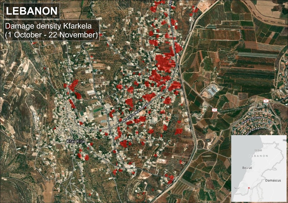
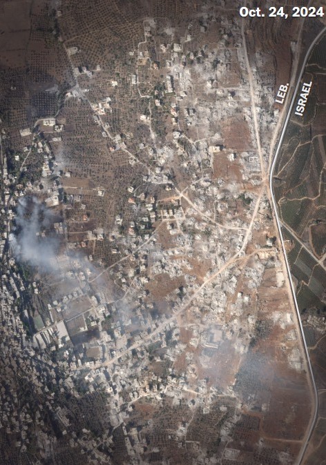
Figure 4 and 5, Detailed example of Damage analysis in Kfarkela, highlighting limitations in image resolution and building footprint overlay capacity of currently available data
Disclaimer
This analysis provides a broad overview of structural damage in Lebanon, focusing on severe impacts as identified through remote sensing. While it serves as a useful tool for preliminary response planning, the limitations of currently available remote data inherently limit the assessment’s accuracy, particularly for minor and moderate damage.
Miyamoto’s experience suggests that the total damage is likely to be significantly higher than the initial analysis reveals. As such, the findings should be viewed as a starting point for further field-based validation and refinement to ensure a comprehensive and reliable damage assessment.
