Remote Sensing Structural Damage Assessment
This report or any part of it should not be reproduced in any form without the written permission of Miyamoto International, Inc.
EXECUTIVE SUMMARY
The technical bulletin presented in this report provides an estimate of the structural damage and shelter needs in the Gaza Strip based on remote sensing data. The report describes the apparent levels of damage in multiple cities, along with a summary of the common building typologies across the area. Color-coded damage maps outline the areas and levels of damage across the region, while pie charts provide a breakdown of probable damage severity. A range of publicly available open-source data, such as UNOSAT, OpenStreetMap, and LandScan Global, were used in this assessment report.
The damage results are produced using UNOSAT data dated April 1, 2024. At that slice in time, more than 50% of the Gaza Strip had been affected, with around 34,000 structures destroyed, 17,000 severely damaged, and 43,000 moderately damaged. Approximately 78% of all buildings in North Gaza were damaged to varying degrees, including moderate, severe, or destroyed, with moderately damaged structures accounting for about 30% of all damaged structures. Similarly, 67% of the building stock in Gaza appears to have sustained varying levels of damage.
At the time of writing this report, the situation in the Gaza Strip has now expanded significantly to the south, resulting in significantly more damage since the last UNOSAT dataset release. It is observed that many of the southern areas of the Strip, such as Khan Younis, Deir Al-Balah, and Rafah, now have suffered a similar level of damage as the north. Approximately 72% of the buildings in Khan Younis and 27% of the buildings in Deir Al-Balah appear to have sustained various levels of damage. As the conflict progresses further south, approximately 10% of the buildings in Rafah are estimated to have different levels of damage.
There are nearly 180,000 structures across the entirety of the Gaza Strip. If damage levels are similar then it is likely that more than 50% of buildings, approximately 1,10,000 structures that are mainly residential, are likely to be damaged and now uninhabitable across the entire area. As a result, approximately 1.2 million people are likely to be without adequate safe housing and in urgent need of emergency shelter and housing recovery assistance. Many more people from non-damaged structures are also likely to be temporarily displaced through fear and lack of adequate services. The UN Shelter Cluster reports 1.9 million internally displaced persons (IDPs) in Gaza, nearly 85% of the population.
Housing recovery and reconstruction efforts in Ukraine and other recent global disasters have shown that once safe access is available, rapid repairs to light to moderately damaged structures can be one of the fastest, most cost-effective, and most dignified ways to address the emergency shelter needs of the affected population. Rapid emergency repairs can also help kick-start early recovery, ensuring a more rapid transition to a permanent, durable solution for those who have been displaced.
Note: The information in this bulletin is based on the most recent available data. Miyamoto intends to update this and provide further updates as new reliable data sources become available.
1. Profile of The Gaza Strip
The Gaza Strip is a narrow strip of land that extends along the Mediterranean coastline north of the Egyptian border. The Strip covers an area that is about 45km in length, with a width that ranges between 6 – 12km, creating a total area of about 360 sq. km (see Figure 1).
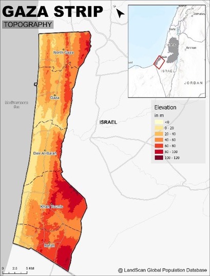
Figure 1: Topography of the Gaza Strip
Recent UN estimates indicate there are approximately 2.1 million people living across the 360sq.km of the Gaza Strip, which includes five major cities and many smaller rural communities. This amounts to an average of more than 5,800 people per square kilometer making it one of the most densely populated areas of the world. Gaza is the largest city in the Strip, covering an area of about 45sq.km. The Topography of the Gaza Strip is dominated by three ridges that run parallel to the coastline as per Figure 1.
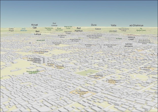
Figure 2: 3D visual block representation of the Northern Gaza Strip (Source: ESRI/OpenStreetMap)
2. Exposure: Built-up Environment and Population
In this section, the built-up area and the exposed population are discussed. Pre-damage building data from the open street maps was analyzed using GIS. Figure 3 shows the details of the urban areas in the Gaza Strip. The total number of buildings is 174,148, encompassing a total ground floor building area of around 49sq.km.
The approximate building and population distribution across the Gaza Strip are shown, respectively, in the two maps below in Figure 3. These maps are based on data from Open Street Maps and the most recent LandScan population data of 1.97M, respectively. While this population data is slightly lower than recent UNRWA estimates of 2.1M, the distribution is likely still relatively accurate. The color-coded heat map shows the hot spots of high population density within the strip. Notably, North Gaza and Gaza are amongst the most highly populated areas within the Strip, with their coinciding high building and population density clearly indicated. The broad distribution of building coverage in the map to the left highlights the high level of less-populated dispersed peri-urban and rural settlements across the area.
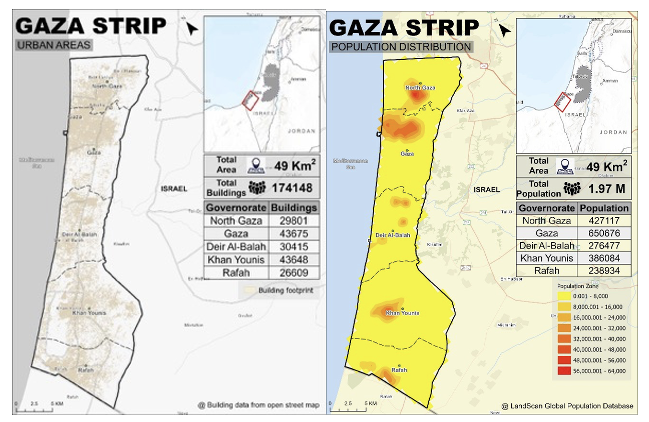
Figure 3: Built-up environment and population distribution
3. Estimated Damage Assessment by Miyamoto International
The following figures demonstrate the estimated damage to structures across the Gaza Strip from the current situation. This damage assessment is based on UNOSAT data from April 1, 2024. As shown in Figure 4, there has been particularly extensive damage to buildings in the cities of Northern Gaza and Gaza. Out of 174,148 buildings in all of Gaza, an estimated 93,829 buildings appear to have been damaged. As per the map below, it is evident that the damage density is much higher in the northern part of the Gaza Strip. The total ground floor built-up area is about 49sq. Km.
As shown in Figure 6, around 34,000 structures have been destroyed, 17,000 severely damaged, and 43,000 moderately damaged. This comprises more than 50% of the total building structures in the Gaza Strip (UNOSAT, April 1, 2024).
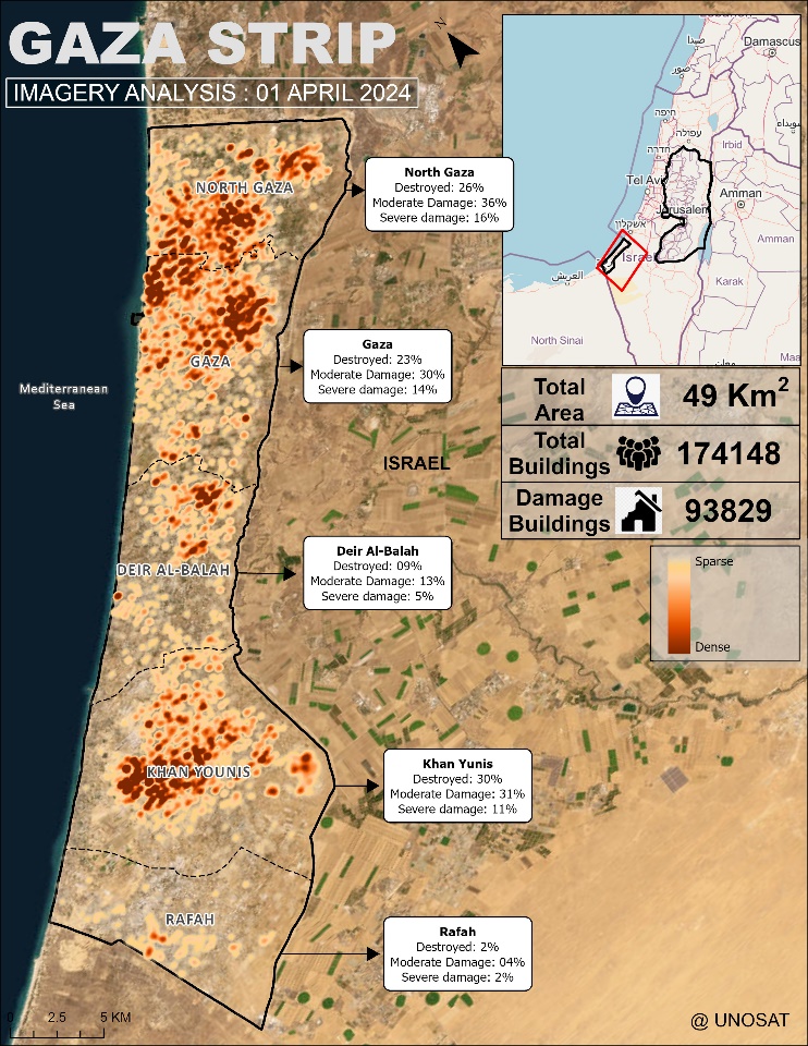
Figure 4: Damaged buildings in the Gaza Strip
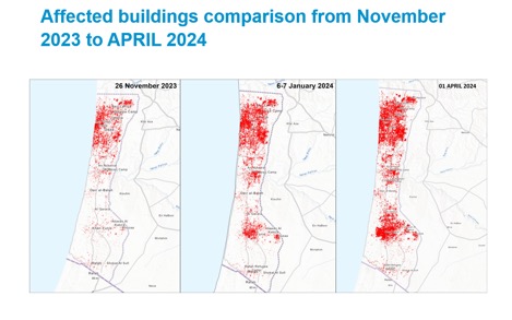
Figure 5: Damaged buildings comparison in the Gaza Strip
As shown in Figure 5, the damaged area has increased in 4 months, from November 2023 to April 2024. There is a significant increase in damaged buildings in Northern Gaza. As the conflict is expanding southwards, we can see the hotspots in South Gaza as well as the Khan Younis Governate.
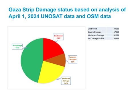
Figure 6: Overall damage in the Gaza Strip
The following pages provide pie charts of building damage levels by region across the Gaza Strip as of April 1, 2024. Figure 7 shows that approximately 78% of buildings in North Gaza have suffered varying levels of damage, from moderate to severe to destroyed. Moderately damaged structures account for about 36% of those damaged structures.
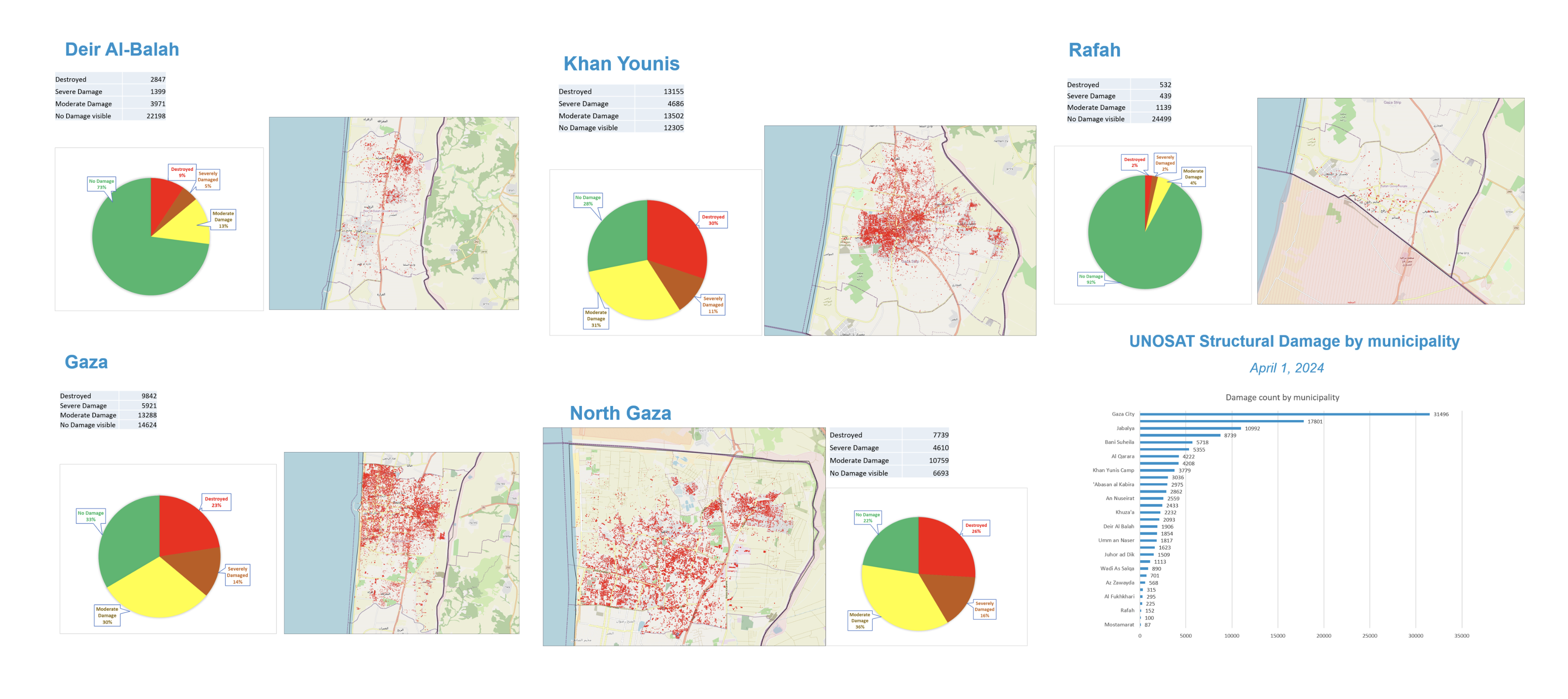 Figure 7: Structural damages across the regions in the Gaza Strip
4. Common Building Typologies in the Gaza Strip
The architectural design of houses in the Gaza Strip has changed dramatically over recent decades, moving from predominantly traditional stone and mud one to two-story courtyard-type construction to predominantly multi-story multi-purpose concrete construction. The rising population density and changes in the availability of building materials appear to have been the major influences in bringing about such rapid qualitative shifts in the creation and design of buildings in general and houses in particular. Based on the predominant construction material, concrete buildings, sandstone buildings, and mud houses are the three common building typologies prevalent in the Gaza Strip.
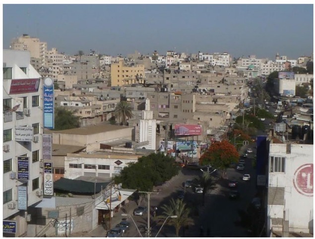
Figure 8: An overview of Gaza City showing the concrete buildings (Source: Muhaisen, 2016)
Most of the new buildings in the major city centers of Gaza are of concrete construction. These buildings vary from lower density one to two-story, single or multi-tenancy houses through to larger multi-story, multi-tenancy, and, at times, multi-purpose buildings. Buildings of this typology are widely constructed using a structural frame system made from reinforced concrete. By and large, roofs are flat concrete, and walls are constructed from plastered concrete hollow blocks, while windows are mostly single-glazed aluminum frames. For a range of reasons, including presumably land availability, cost, and availability of skills and materials, concrete houses now appear to be the preferred building typology for most residents over sandstone and mud houses. Figures 8 and 9 show examples of concrete buildings in Gaza.
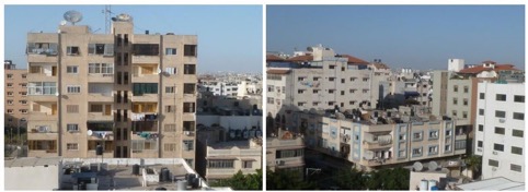
Figure 9: Multi-story concrete buildings in Gaza (Source: Muhaisen, 2016)
The second building type which used to be common in Gaza is sandstone houses. Sandstone had been used in Gaza over very long periods of time. The houses are built mainly of sandstone with a load-bearing wall structural system. The walls are thick enough to bear dead and live loads, with some of the crevices in the wall used as small shelves for storage. The roofs are commonly made of sandstone and take the form of intersecting vaults based directly on the walls appearing flat from above. The houses consist mainly of one floor and, in some cases, two floors maximum (Muhaisen, 2016). Typical sandstone Gaza houses with crevices are shown below in Figure 10. This building type is not so prevalent now in Gaza.
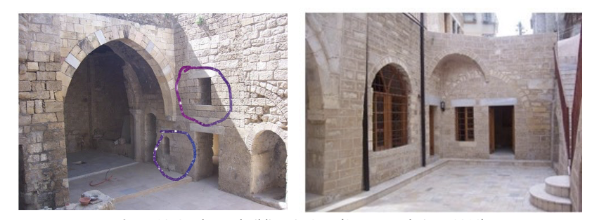
Figure 10: Sandstone buildings in Gaza (Source: Muhaisen, 2016)
The third building typology in the Gaza Strip is mud or clay construction. These buildings are rarely seen in inner city areas but can be found across peri-urban and rural areas. Buildings of this typology are constructed mainly from clay, as the base building material. Clay blocks are used to construct the walls, and clay is also used to construct flat roofs, which are commonly supported by branches of locally available trees, such as palm, sycamore, and eucalyptus.
Some examples of mud houses are shown in Figure 11.
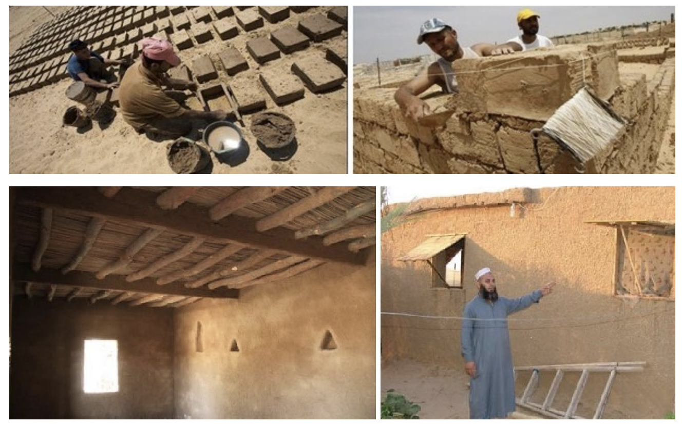
Figure 11: Traditional Mud House in Gaza (Source: BBC, 2009)
CONCLUSIONS
Open-source data dated April 1, 2024 (from UNOSAT, OpenStreetMap, and LandScan Global) was used for the analysis of housing damage, as well as to provide an initial estimate of probable shelter and housing recovery needs. This data shows that in northern Gaza, approximately 78% of the building stock had sustained damage to varying degrees. The evolving situation in the Gaza strip has since expanded considerably to the south since the release of the last UNOSAT dataset, and it is expected that this region will have sustained similar levels of damage as the areas to the North. It is also evident from the damage data. It is estimated that approximately 72% of the buildings in Khan Younis and 27% of the buildings in Deir Al-Balah appear to have sustained various levels of damage. In this case, approximately damage levels are now likely to be around 1,10,000+ structures (mostly residential), leaving an estimated 1.2 million+ people without adequate housing. The UN Shelter Cluster reports 1.9 million internally displaced persons (IDPs) in Gaza, nearly 85% of the population. Miyamoto intends to update this Technical Assessment report as soon as more up-to-date datasets on damage become available.
On-ground rapid assessments will, of course, be required to verify these remote-data-based damage assessments and more accurately identify the shelter and housing recovery needs of the affected population. However, initial analysis indicates that about 50% of damaged structures are likely only moderately damaged and are readily repairable. Housing recovery efforts in Ukraine and other major global disasters have shown that rapid repairs to moderately damaged structures can be one of the fastest and most dignified ways to address immediate shelter needs as and when the current situation stabilizes, and safe access can be assured. The early provision of technical support and cash for rapid repairs to moderately damaged housing stock may diminish the need for other costly and often prolonged emergency shelter solutions while providing a rapid pathway to a durable housing solution for many of those currently displaced.
REFERENCES
British Broadcasting Corporation (BBC) (2009)
Fulaih N. and Ali H. Assessment and Repair of Damaged Concrete Structures Due to War
Case Study (The Republic of Yemen), International Journal of Engineering Research & Technology, Vol. 11, Issue 01 (January 2022)
LandScan Global (2024)
Muhaisen A. (2016). Development of the House Architectural Design in the Gaza Strip, Athens Journal of Architecture.
The World Bank – Gaza Damage Assessment Bi-Weekly Report (2024)
OpenStreetMap (2024)
United Nations Satellite Centre (UNOSAT) (2024)