An Outlook on Landslides in Indone…
Country Profile: Indonesia
The Republic of Indonesia, herein Indonesia, is the world’s largest archipelagic state, consisting of over 17,500 islands with over 81,000 kilometers (km) of coastline.1 The country’s islands are home to an extremely varied geography, topography, and climate, ranging from sea and coastal systems to peat swamps and montane forests.2 Geologically, positioned at the convergence of the Pacific, Eurasian, and Australian tectonic plates, Indonesia is one of the most dynamic tectonic regions worldwide.3 Morphologically, Indonesia consists of lowland (0–500 m), hilly land (500–1000 m), upland (1000–2000 m), and mountain (more than 2000 m). Indonesia has a population of over 273 million (2020), and at present, it is the world’s fourth most populous nation.
Disaster Profile of Indonesia
Indonesia stands out as one of the most disaster-prone nations globally, facing frequent exposure to various hazards. The country’s natural disaster risk index for events like tsunamis, floods, landslides, droughts, and forest fires is notably high compared to global standards. Consequently, positioned within such a dynamic geological zone and characterized by a dense population, Indonesia regularly experiences various geological disasters, resulting in significant loss of life, casualties, and socio-economic damage. Beyond the intricate geology, human activities have exacerbated communities’ vulnerability to numerous hazards. Extensive urban development, often lacking proper planning and regulation, has heightened cities’ susceptibility to natural calamities. The process of urbanization, driven by natural population growth and rural-to-urban migration, has expanded cities’ exposure to such hazards. Newly arrived urban migrants and settlements frequently settle in vulnerable areas, including flood-prone regions and steep hillsides. Environmental degradation and deforestation stemming from poorly managed urban population growth, land scarcity, and commercial activities are major contributors to pluvial floods and landslides. According to the Indonesian National Agency for Disaster Management, Indonesia has been struck by 6,632 events of natural disasters (mainly geological disasters) within the period of 1997–2009, with a total death toll of 151,277 people.5 Moreover, the Indonesian Disaster Management Authority (BNPB) data indicates that the number of disaster events in Indonesia increased significantly from 2010 to 2019.5
Landslides in Indonesia
Landslide is one of the most frequent disasters in Indonesia. According to BNPB (2020), the frequency of landslides in Indonesia has risen over the past decade, resulting in a wider distribution of disaster-affected areas. This trend is attributed to increased land use practices that are not environmentally friendly, coupled with heavy and prolonged rainfall and a rise in earthquake occurrences. Many areas prone to landslides are fertile lands with ample groundwater, which have been developed for settlements, agriculture, and infrastructure construction. Consequently, the relocation of settlements and infrastructure is challenging. Thus, several factors, including population density, infrastructure quality, economic status, and regional capacity, contributed to landslide risk.
It is estimated that about 108.8 million people live in moderately to highly landslide-susceptible zones, out of which 15.2 million live in highly susceptible zones in 228 districts in Indonesia.7 Furthermore, the landslide hazard map of Indonesia, as released by BNPB 2020, indicates the areas with a high risk of landslides are those in the western parts of Sumatera Island, along the Bukit Barisan mountain belt; the southern and central parts of Java Island, Bali, Nusa Tenggara, almost every part of Sulawesi Island, Maluku, the southern and central parts of Papua. In Indonesia, the collective population exposed to the risk of landslides amounts to 194 million individuals, with a potential financial loss estimated at USD 13 billion.8
Despite the publication and availability of the Landslide hazard maps for geological disasters in the public domain and mitigation efforts, landslides are causing casualties. The prominent reasons are: (i) the number of settlements and public activity in medium and high susceptibility areas are still growing, (ii) landslide susceptibility maps & EWS (early warning system) are not being optimally used as a database for planning and regional development and (iii) early education in school concerning the geological hazard such as landslides as a part hazard management, has not been formally introduced in the school curriculum.
One of the recent landslide incidents in Indonesia’s West Java on March 24, 2024, occurred after torrential rain poured over the area for about two hours. The landslide incident claimed one dead and nine missing, while 400 villagers had to flee to temporary shelters as dozens of houses were destroyed. The most prominent reason for the occurrence of this landslide is incessant rainfall. Nevertheless, the problem has been aggravated in some places by deforestation, with prolonged torrential rain causing flooding in some areas of the archipelago nation.

Photo by sumaryanto bronto on Flickr
Strategies to Bolster Resilience against Landslides in Indonesia
To minimize the impact of landslides, several structural methods (such as modification of slope geometry, slope reinforcement and retention, drainage management, and relocation to safer areas for people living in high-risk areas) and non-structural mitigation measures (such as community knowledge and preparedness, improving institutional capacity building, all supported by policies and regulations) exist. However, due to limited financial resources, developing countries like Indonesia have difficulties building facilities or constructions to protect an area from natural disasters. Furthermore, the effort to relocate residents to a safe area is also very expensive and impracticable. Since the landslide risk in this area is controlled primarily by the geology, climate conditions, as well as the high vulnerability of socio-economic conditions, the most promising mitigation approaches can be addressed by incorporating four pertinent components:
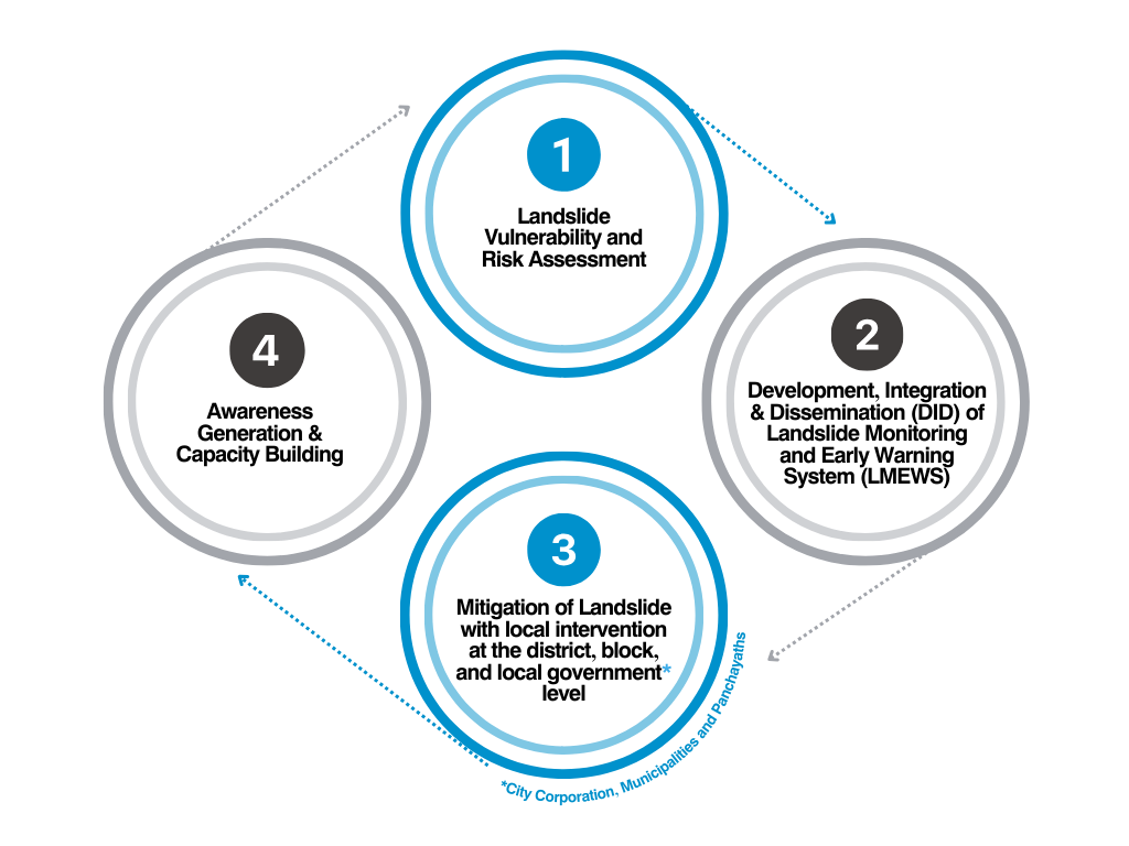
1. Landslide Hazard Zonation Maps
Communities should refer to the Landslide Hazard Zonation Map before planning for any development activity, public works, and construction of housing settlements. Landslide hazard zonation maps will pinpoint safer zones, control land utilization, establish rules regarding the placement, orientation/size/height / and function of structures within each zone, and establish building codes based on the design and intended use of structures.
2. Landslide Monitoring & Early Warning System (EWS)
Since the occurrence of landslides in Indonesia is primarily rainfall-induced, instruments such as piezometers, soil moisture sensors, and automatic rain gauges can be installed for landslide early warning & real-time monitoring.
Slope monitoring devices, such as inclinometers, extensometers, and GPS sensors, can be used to detect early signs of slope instability.
3. Mitigation of Landslide with local intervention at the local government level
a) Drainage Management
Inadequate surface drainage maintenance could exacerbate and lead to large landslides even on engineered slopes. Thus, adequate water drainage is the most important element of a slope stabilization scheme. Drainage can be either surface (chute, cascade, longitudinal/cross-drains, etc.) or subsurface (drainage galleries, horizontal drains, well points, etc.).
b) Use of vegetation as a Nature-Based Solution (NbS):
Vegetation holds the potential to mitigate erosion, underscoring the importance of enhancing the presence of erosion-preventing plants like teak trees, both within residential areas and across the environment, particularly on slopes.
Re-vegetation to control groundwater and rainwater for strengthening the slope with specific kinds of (native) plants.
c) Infrastructure Resilience:
Along with improving planning and practice for future development, addressing the existing vulnerability of existing urban infrastructure stock is imperative. This entails activities that include a systematic assessment of risk levels in target areas or infrastructure types with prioritization and technical standards and guidelines for city-wide retrofitting programs (addressing, for example, foundations, structural framing, external facades, roofing, interior finishes, etc.) by integrated building information systems and early warning systems.
Design the house with split levels to minimize disturbance to the hill slope, thus controlling erosion and earth slip.
All elements of the building should be properly tied together. Connections between posts, beams, columns, and wall-to-wall framing should be ensured, as this prevents the structure from breaking into separate elements.
The house shall be parallel to the contour lines and not perpendicular.
Structures should be built safely against sliding and overturning, possibly through engineering practices.
4. Awareness Generation and Capacity Building:
Continuing training and education programs can increase public awareness. Delivering disaster knowledge with effective mitigation strategies and guidelines is challenging when dealing with capacity building and community preparedness in disaster-vulnerable areas. This activity will increase community knowledge to prevent landslides and protect themselves if there are landslides in the future.
Early education in school concerning geological hazards as part of hazard management shall be included formally in the school curriculum.
While disasters like landslides aren’t always evitable, with the knowledge and resources provided by this solution, we can mitigate the impact of disasters and swiftly recover, fostering resilience in the face of adversity.
References
1. World Bank (2020). Indonesia – Overview. URL: https://www.worldbank.org/en/country/indonesia/overview
2. Naylor, R., Battisti, D., Vimont, D., Falcon, W., Burke, M. (2007). Assessing Risks of Climate Variability and Climate Change for Indonesian Rice Agriculture. Proceedings of the National Academy of Sciences of the United States of America. 104. 7752–7. URL: https://www.pnas.org/content/pnas/104/19/7752.full.pdf
3. Ngadisih, Samodra, G., Bhandary, N.P., Yatabe, R. (2017). Landslide Inventory: Challenge for Landslide Hazard Assessment in Indonesia. In: Yamagishi, H., Bhandary, N. (eds) GIS Landslide. Springer, Tokyo. https://doi.org/10.1007/978-4-431-54391-6_8
4. https://www.statista.com/topics/8305/natural-disasters-in-indonesia/#topicOverview
5. F. Wang et al. (eds.), Progress of Geo-Disaster Mitigation Technology in Asia, Environmental Science and Engineering, DOI: 10.1007/978-3-642-29107-4_7, Springer-Verlag Berlin Heidelberg 2013
6. Fathani, T.F., Karnawati, D., Wilopo, W., Setiawan, H. (2023). Strengthening the Resilience by Implementing a Standard for Landslide Early Warning System. In: Sassa, K., Konagai, K., Tiwari, B., Arbanas, Ž., Sassa, S. (eds) Progress in Landslide Research and Technology, Volume 1 Issue 1, 2022. Progress in Landslide Research and Technology. Springer, Cham. https://doi.org/10.1007/978-3-031-16898-7_20
7. BNPB (2020) Risiko Bencana Indonesia (RBI). Direktorat Pengurangan Risiko Bencana, BNPB, Jakarta. https://bnpb.cloud/dib.
8. BNPB (2019) Risiko Bencana Indonesia (RBI). Direktorat Pengurangan Risiko Bencana, BNPB, Jakarta. https://bnpb.cloud/dib.
About the Author
Aditi Singh, Ph.D. 
DRR Technical and Research Expert
Miyamoto Global Experts India
Dr. Aditi Singh is a Disaster Risk Reduction Technical and Research Expert at Miyamoto Global Experts India Pvt. Ltd., where she applies her civil engineering expertise and research experience to contribute to the company’s disaster risk reduction initiatives. Her work involves vulnerability and risk assessments, mitigation strategies, and the use of advanced technologies like remote sensing and GIS for disaster management. With 5 years of research experience and 3 years of teaching experience in the Department of Civil Engineering at Sarala Birla University, Ranchi, Dr. Singh has published extensively in SCI-indexed journals and book chapters, focusing on applying civil engineering knowledge to address landslide hazards, vulnerability, and risk assessment.